10 Dec 2024
Like waves crashing to shore, it seems disasters just keep coming – devastating hurricanes in Florida and floods in Spain are just two recent examples. But with every disaster comes the opportunity to learn and to increase preparedness and resilience for the inevitable “next time”. We take a look at the roles engineers play and how best practices evolve, based on experiences here and abroad.
On Boxing Day in 2004, an undersea earthquake in the Indian Ocean triggered a devastating tsunami that damaged coasts of countries across South and Southeast Asia. The series of massive ocean waves caused immense destruction and the loss of hundreds of thousands of lives.
The Indian Ocean tsunami spurred action to examine and enhance the level of tsunami resilience across Aotearoa, and two decades on, a lot has changed here when it comes to disaster preparedness and resilience.
“It has led to 20 years of advances across most facets of tsunami, especially tsunami warning and preparedness,” says Graham Leonard, a principal scientist at GNS Science whose research centres on characterising and mitigating the impacts of natural hazard events.
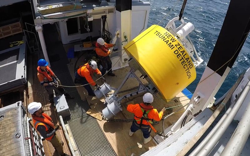
A Deep-ocean Assessment and Reporting of Tsunami (DART) buoy being deployed in the Southwest Pacific.
Since then, a national framework for tsunami evacuation zones was developed, along with establishing a 24/7 National Geohazards Monitoring Centre. The ongoing transition from geographic information systems to more modern hydrodynamic models for tsunami modelling is also a key change.
Emergency mobile alerts were set up following the 2016 Kaikōura earthquake and tsunami and in 2019 a network of DART (Deep-ocean Assessment and Reporting of Tsunami) buoys were strategically deployed off the east and north coasts of Aotearoa. These deep ocean pressure sensors can detect a tsunami and help experts provide early warning before it reaches our shores.
The DART buoys proved valuable in picking up signs of tsunami activity and supplying data to estimate the tsunami threat to our coastlines after the explosive eruption of Tonga’s Hunga Tonga-Hunga Ha’apai volcano in January 2022.
… thousands of people had their lives saved by evacuating upwards inside strong buildings.
“The Tongan tsunami highlighted that we need to do more work on our modelling for a volcano source – how big a tsunami might be generated and the mechanisms behind it,” Graham says.
His experience throughout the Asia-Pacific region and in North and South America has helped inform his work in Aotearoa. His contribution to the “long, strong, get gone” educational campaign for earthquakes and tsunamis was inspired by visits to Thailand in 2006, Indonesia in 2008, and Japan after the earthquake and tsunami in 2011. He discovered the importance of regular earthquake and evacuation drills for the community, and that people who evacuated feeling a long or strong earthquake alone or other natural signs, without waiting for a siren or emergency mobile alert, had the best survival rate.
Vertical evacuation
Graham is currently working with the New Zealand engineering community on a technique he has studied in Japan called vertical evacuation.
“We could see how valuable buildings were in big, flat coastal areas as a place people could be safe,” he says.
“As long as they were reinforced concrete or steel and taller than the water flow depth, they survived very well. And thousands of people had their lives saved by evacuating upwards inside strong buildings.”
While guidance is already in place for designing new vertical evacuation structures for tsunami loads in Aotearoa, more guidance is needed for evaluating existing buildings “so that the strongest buildings can have a message that people stay in them, leaving enough capacity on the streets for people from weaker buildings to evacuate from a tsunami”, Graham says.
Looking to the future, he hopes for a more holistic approach to disaster preparedness and resilience in Aotearoa.
“I hope we are building our communities and infrastructure in ways that will be less damaged by a tsunami over the next 50 years. And balancing that against other hazard risks too, like coastal erosion, flooding and earthquakes, so that we’re picking the most resilient, safest places for our new buildings.”
Tsunami resilience in the Pacific
Vensel Margraff is a doctoral researcher at the University of Auckland investigating tsunami resilience in Pacific Island communities. As a civil and environmental engineering undergraduate, he developed and applied a spatial framework to assess coastal protection in Tonga.
For his doctoral dissertation, Vensel, who won the Outstanding Emerging Professional Award at Engineering New Zealand’s 2024 Auckland Branch Awards, is expanding that framework to include Samoa. He’s putting it to practice, developing geospatial models that incorporate agent-based modelling and machine learning techniques. These models will characterise not only the physical and economic dimensions but also the social dimensions of when a community is impacted by tsunami hazards.
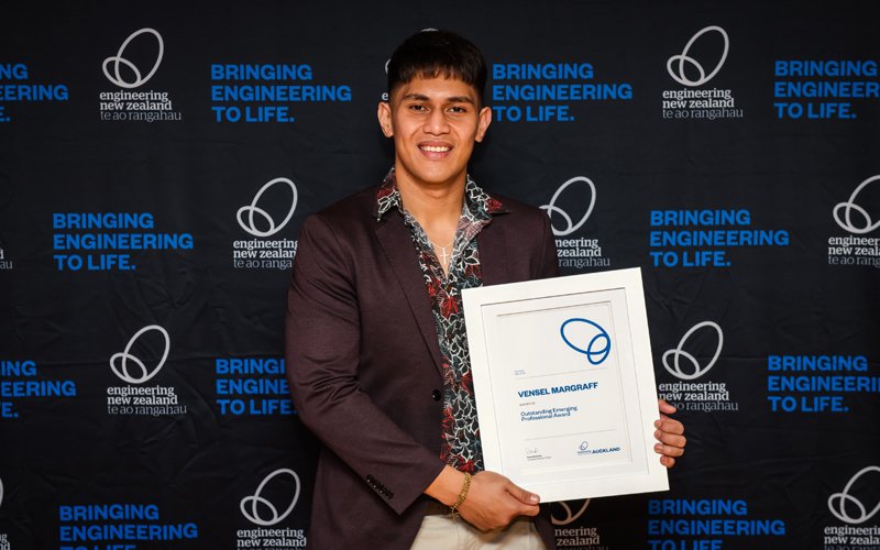
University of Auckland tsunami resilience researcher, Vensel Margraff. Photo: Engineering New Zealand/Jeremy Hill Photography
“Hopefully, the work will support policy-makers and decision-makers to optimise resource allocation and improve disaster response strategies locally,” he says.
Vensel noticed that the current state of practice in the disaster response space has been reactive.
“New methodologies only come out when a disaster happens,” he says.
“However, by adopting a resilience mindset, you become more proactive to disasters, which improves the overall preparedness of the community.”
Vensel grew up in Samoa, which makes his research on tsunami resilience all the more meaningful.
“I’ll get to contribute back to my home by designing and implementing solutions there, but also use my experience as a local to extract information about what they need,” he says.
“As I’ve continued in this path, I’ve realised it’s less about how technically savvy your solutions are and more about how contextualised they are to the local circumstances because that is what will make the biggest difference in people’s lives.”
Earthquake resilience
Earthquakes are another natural disaster Aotearoa is familiar with. Throughout his five-decade-long career, structural engineer Barry Brown MNZM DistFEngNZ IntPE(NZ) has witnessed myriad shifts in thinking and practices around earthquake resilience.
Random processes turned into rigorous standards. These include the introduction of limit state codes for structural steel and reinforced concrete, detailing rules for structural members potentially subject to seismic overload, capacity design for permissible collapse mechanisms, and sophisticated software for analysing earthquake response in buildings.
“This promoted a more prescriptive approach to structural design in place of the nominal processes applied previously to achieve compliance,” Barry says.
“Consequently, the structural engineer’s task in designing earthquake resilience into buildings at the end of my professional career in 2020 was much more demanding than it was when I started in 1970.”
These transformations have led to strengthened earthquake resilience here, especially for newly constructed buildings. However, more effort is needed to retrofit existing buildings to meet modern earthquake resilience standards.
“The challenge in terms of improving earthquake resilience is that what you can do with a new building you can’t always do easily with an existing building,” says Barry. He adds that residential and commercial buildings also have different resilience considerations because of the different roles they play in our lives – any lack of resilience impacts on us differently as owners, tenants or workplace users.
Measuring a change in resilience is a challenge as well, since it goes beyond a drop in the number of earthquake-prone buildings.
“We need to think of resilience on a wider front than just earthquakes,” Barry says. “We need to consider it in the context of land and natural hazards that might affect that land.”
This year, Barry was made a Member of the New Zealand Order of Merit for services to structural engineering. Reflecting on his career, he’s most proud of his accomplishments as Chair of the Building Industry Authority between 2001 and 2005, supporting the recovery team mobilised in response to the 2011 Christchurch earthquakes, and establishing the New Zealand Structural Engineering Society in 1988.
“I’m proud of the way that entity has developed into a force for good and best practice in the structural engineering field.”
Resilience reconnaissance
In April this year, a magnitude 7.2 earthquake rattled Hualien County in Taiwan, its strongest seismic event in 25 years. Dr Ke Jiang MEngNZ, a lecturer in civil and natural resources engineering at the University of Canterbury, travelled to Taiwan on a reconnaissance mission to study the performance of retrofitted buildings after the earthquake.
Ke observed the rapid post-disaster recovery, with the city remaining functional even after the earthquake. She also noted the swift restoration of earthquake-damaged infrastructure, with major structural deficiencies addressed through simple building retrofits.
It’s also important to accelerate the transition to post-disaster recovery and maintenance.
She attributes this speed to immediate decision-making and efficient damage assessments. Structural engineers promptly appraise and design repairs. Hospitals, schools, and other essential infrastructure are a priority, followed by residential buildings and other structures. Retrofits are partially subsidised by the government.
Ke shares a few lessons learned from Taiwan that can be applied to Aotearoa. For instance, early warning systems and periodic earthquake drills proved effective in reducing casualties.
“It’s also important to accelerate the transition to post-disaster recovery and maintenance,” she adds.
“To do that, we need straightforward guidance for damage assessment of different building types, as well as effective retrofitting techniques.”
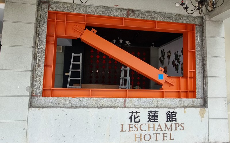
Buckling-restrained brace used to retrofit the Les Champs Hotel in Taiwan. Photo: NZSEE
Engineers to the rescue
With frequent earthquakes and increasingly intense rainfall, Aotearoa is no stranger to landslides. When slips happen, the Urban Search and Rescue (USAR) team at Fire and Emergency New Zealand is quick to respond.
The team is unique in that it includes geotechnical engineers.
“Engineers being embedded are generally structural engineers because we train for building collapses,” says Dr Jan Kupec FEngNZ CPEng IntPE(NZ), a geotechnical principal at Aurecon and USAR engineer.
“It requires a structural mindset and technical skillset to operate in that high hazard environment.”
While Jan is typically deployed when incidents occur across the country, particularly during the Christchurch and Kaikōura earthquakes and more recently during the 2023 flooding in Auckland and Hawke’s Bay, he also helps out with missions abroad.
In the wake of the deadly landslide that rocked the Yambali village of Papua New Guinea in May 2024, Jan was part of the team sent to evaluate conditions on the ground. His role involved determining the size of the landslide, its likelihood to mobilise and cause further slips, and who were at risk downstream, among other factors.
“The deployment is a highly dynamic, active environment. You are often with minimum communication to the outside world. You need to do snap assessments and make fast decisions,” Jan says.
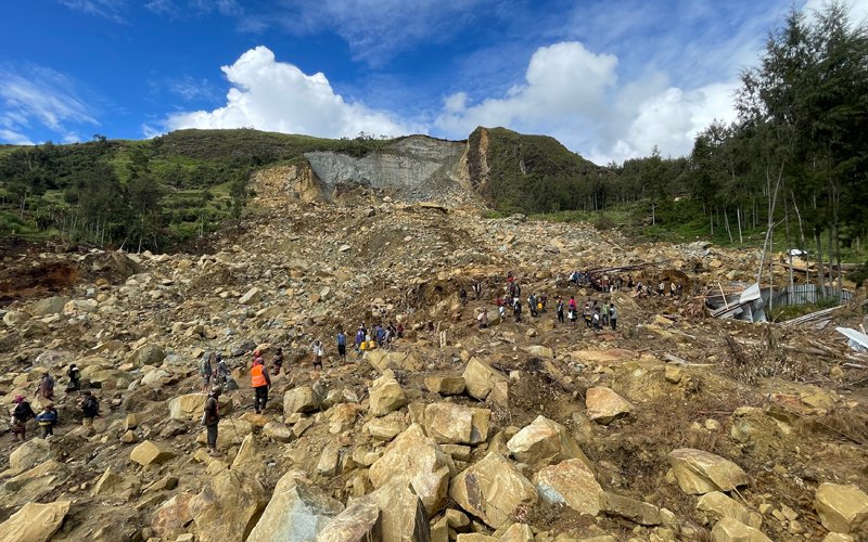
Local villagers cross a 200m-wide landslide in Papua New Guinea's Enga Province. Photo Jan Kupec
Technology is critical in USAR. In the case of the Papua New Guinea landslide, the team used high-resolution satellite images to gather highly detailed topographical information, and deployed drones to capture images and videos. These were processed into digital 3D maps and sent to a team at GNS Science, who combined this information with current and historical aerial photographs and fed the data into numerical models.
These models were calibrated using data from past events, such as the Christchurch earthquakes, avalanches in the Swiss Alps, and observations of landslides in the Wellington region. The model was then able to predict hazard information, including where a landslide started and where it would end up, as well as its movement and behaviour.
“The model was able to predict areas at risk, and that was information we were able to provide to the Papua New Guinea government,” says Jan.
He also worked with local engineers in Papua New Guinea to pass on the information gathered.
These engineers were invited to New Zealand in November as part of a knowledge exchange and capability building exercise.
“The idea is for them to understand how we tackle these problems and what solutions we use, and essentially enable a collaboration,” Jan says.
“We wanted to be part of the solution development and build up capability that enables the people of Papua New Guinea to react to future incidents like this.”
This article was first published in the December 2024 issue of EG magazine.

