22 Jan 2025
Northland Regional Council’s Otiria-Moerewa spillway and bridge flood mitigation project highlights how engineering can be a catalyst for positive change for people and places.
In the past decade, the small Northland communities of Otiria and Moerewa have suffered four significant flood events, often flooding homes, marae and the local rugby club to more than half a metre deep. This recurring disaster prompted the formation of the River Liaison Committee in 2017, a collaborative effort between tangata whenua and local government, designed to tackle the flooding issue.
The committee comprised iwi groups, landowners, Regional and District Councils, local hapū, Waka Kotahi (NZTA) and KiwiRail. This project was co-funded by the Council and Kānoa – Regional Economic Development Unit. The goal was to develop a comprehensive engineering solution to manage the 250km2 catchment area effectively.
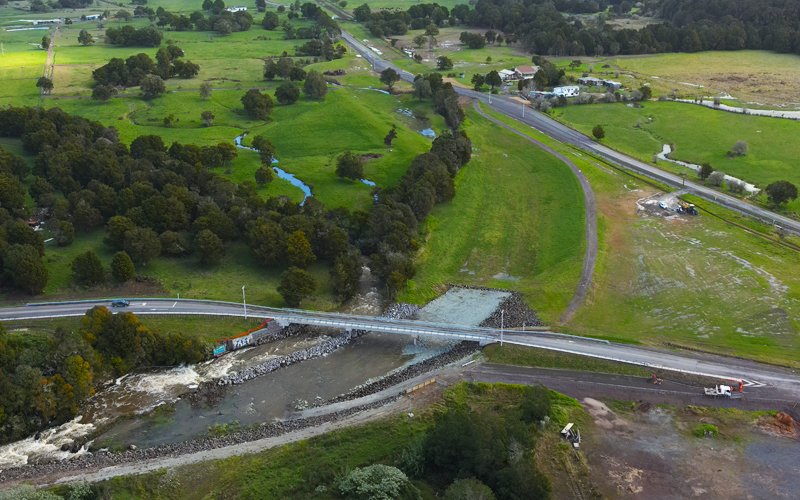
Looking upstream at the completed construction site, the spillway travels from the Otiria Stream at the north end of the valley under Ngapipito Road (box culverts) and under the new Pokapu Road Bridge where it flows out into the Waiharakeke River. Photo: Northland Regional Council
Civil engineer Joe Camuso MEngNZ, affectionately known as “Uncle Joe” to the locals, was Project Sponsor for Northland Regional Council Te Kaunihera ā rohe o Te Taitokerau (NRC). Alongside a team of 16 engineers – consisting of hydraulic modellers, civil, geotechnical, structural and environmental engineers – an essential part of his role was creating this collaboration between the stakeholders.
“At the very start of the project, kaumātua Murray Armstrong stood up and told us what he had witnessed over the decades and how the natural flow of the water had changed since human habitation,” says Joe.
“It was essential to integrate this local knowledge into the overall plan and to have tangata whenua involved at the discussion table and decision-making process.”
His team’s early observations corroborated local knowledge, suggesting that roads and railroads were obstructing the river’s natural path, redirecting floodwaters towards populated areas.
To address this, the team employed LiDAR technology to create highly accurate topographic maps. This technology provided a digital terrain model of the catchment area and allowed the team to identify the human made environment of roads, railroads, marae and houses.
“We removed the manmade environment, creating a ‘pre-human’ base case.”
This enabled hydraulic and civil engineers to visualise, analyse and compare the impact of human-made structures on flood dynamics. From this base case, they then looked at ways to mimic Mother Nature and restore Te Mana o te Wai the mana of the awa.
Essentially the project was about “re-wilding” the waterways, Joe says.
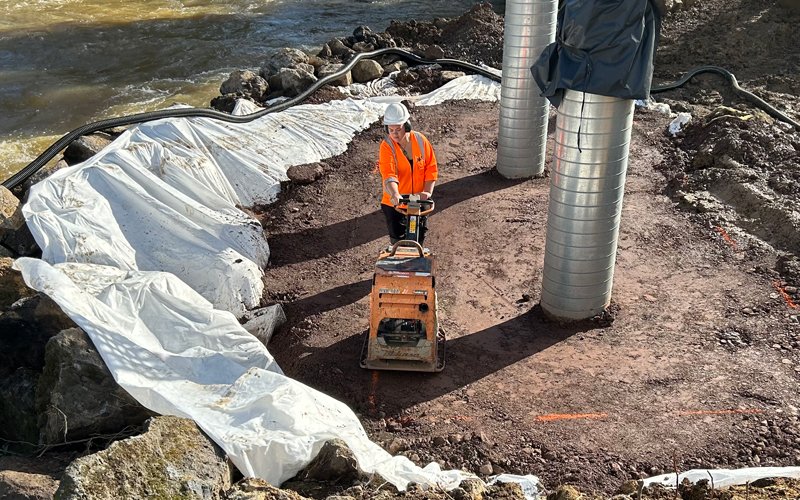
A construction worker from Ventia compacts material surrounding a pier as part of the Pokapu Road Bridge project. Photo: Ventia
“This involved designing a significantly larger bridge – from the existing 18-metre-wide bridge to a 60-metre-wide structure – to accommodate floodwaters. The construction of a spillway meant that the flood water was directed from old paleo channels into the main river system of Waiharakeke River past the lava flow, where the river is considerably wider and deeper.”
For Chantez Connor-Kingi, Kai whiri iwituna Senior Advisor – Rivers and Natural Hazards at NRC, the restoration effort was not just about engineering, but about honouring Te Ao Māori and highlighting the importance of cultural sensitivity and partnership to achieve success. By restoring the river’s natural flow, the project aimed to restore the river’s mana, reflecting respect for the land and its people.
“The success of the project stemmed from an authentic collaboration based on the principles of partnership outlined in te Tiriti o Waitangi,” says Chantez.
“This was achieved by incorporating both Māori mātauranga (knowledge) and Western science to address environmental concerns, particularly around land use and water management.”
Chantez continues: “Traditionally, such projects involved hiring external providers and not really listening to the people.”
So, a different approach was taken.
“We organised a six-day on-site wānanga, bringing together local hapū members ranging from elders to young children, and a team of in-house scientists and engineers, to learn about the rivers and the land. The presence of Māori for Māori allowed the community to engage in hands-on activities, where everyone could learn from each other.”
The wānanga also facilitated strong relationships between the project team and the hapū, fostering a sense of ownership of, and support for, the project. This high level of engagement proved crucial in navigating potential conflicts and building trust.
“The land for the bridge was Māori-owned, and the project team faced challenges related to historical grievances over land use and compensation,” says Chantez.
“Initially there was resistance. But by listening to the people, we came up with a resolution over an 18-month period, ultimately leading to a fair lease agreement. This agreement included a 100-year lease paid up front, reflecting a commitment to addressing historical injustices and fostering good relationships with the local community.”
[Pull Quote] It was essential to integrate this local knowledge into the overall plan and to have tangata whenua involved at the discussion table and decision-making process.
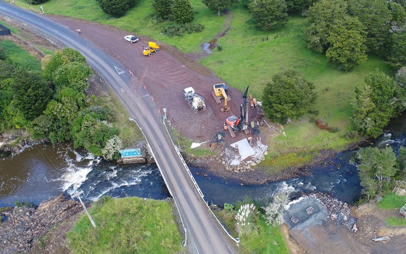
Bird’s-eye view of the new 60m-long Pokapu Road Bridge under construction. Photo: Northland Regional Council
Local River Liaison Committee member Pamela-Anne Ngohe-Simon agrees with Chantez, saying: “This project was never just about the flooding for us.”
Pamela-Anne lives just 100m from the spillway and was kaitiaki (cultural observer) during stage one of the project.
“When it flooded, it wasn’t just water that came into our homes, but also the septic tank flooding. It was affecting the health of our people.”
Pamela-Anne says collaboration was key.
“For once the land was not forcibly taken from us under the Public Works Act. This may be a first in New Zealand’s history. This showed a genuine partnership with the community, ensuring that future generations would not face Treaty of Waitangi claims or unresolved grievances. NRC was honourable through this process and wasn’t afraid to fix mistakes.”
This article was first published in the December 2024 issue of EG magazine.

