Wellington’s Centennial Highway, commemorating the centenary of the signing of the Treaty of Waitangi, still follows some of its original route from Ngauranga Gorge through to Paekakariki. Newer sections include the motorway that now bypasses Tawa township.
Planning for New Zealand’s 1940 Centennial began in the mid-1930s and was publicly funded. The events and works were a deliberate act of national self-definition by the first Labour Government. The Centennial was to be a catalyst for rekindling the spirit of progress in post-Great Depression New Zealand. The Government undertook a large number of public works projects that required manual labour, such as road building, which reflected both an early pioneer ethos and progress.
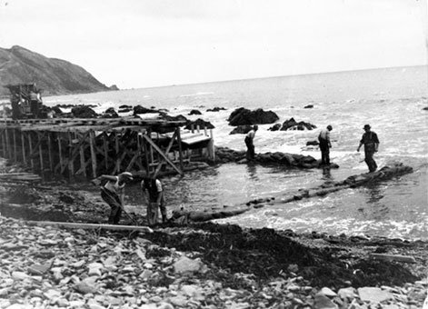
Centennial Highway (Paekakariki Coast Road) under construction, Wellington [circa 1939]. Beattie, Mr: Photographs and negatives relating to the construction of Paekakariki Road. Ref: 1/2-115766-F. Alexander Turnbull Library, Wellington, New Zealand, URL: http://beta.natlib.govt.nz/records/22481321.
While not initially conceived as monuments, the Ngauranga Gorge, Hutt Road and, particularly, the Coastal Road developments were rebranded as symbols of progress. At the opening of the Coastal Road in November 1939, much was made of the fact it had been constructed alongside the pre-1848 coastal route.
The objective of the new highway was to replace the Paekakariki Hill Road as the main route between Wellington and Paekakariki. The Road largely followed the route of a military road built on the line of a Māori track in the 1840s and was not suitable for modification to suitable standards for "modern" motorised traffic.
Paremata to Paekakariki section
The construction of the road section between Paremata and Paekakariki commenced, in late September 1936, shortly before the opening of the Paremata Bridge.
The section was an important and demanding project for the Public Works Department (PWD). It offered many significant challenges for engineers and builders alike. It was constructed on a wide variety of land forms – sand dunes through Paremata, swamp land through Plimmerton, carved-out hillsides at Pukerua Bay and required extensive sea-walling along the coastal strip between Pukerua Bay and Paekakariki.
The engineers for the project included J Wood (PWD Engineer in Chief), H Watkinson (PWD Wellington District Engineer) and HL Hume (PWD Engineer in Charge).
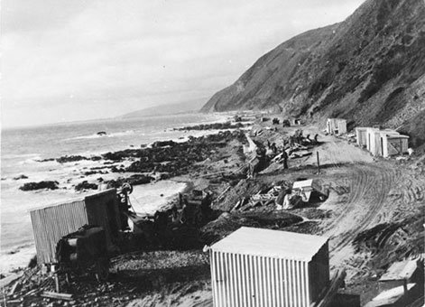
Raine, William Hall, 1892-1955. Centennial Highway, Wellington region - Photograph taken by William Hall Raine [circa July 1949]. New Zealand Free Lance: Photographic prints and negatives. Ref: PAColl-8983-67. Alexander Turnbull Library, Wellington, New Zealand, URL: http://beta.natlib.govt.nz/recor
While many of the road workers came from the local area, PWD camps were also set up including one at Plimmerton on the eastern side of the railway line before the township, and one at Tawa (Taua) Tapu near Airlie Road. These workers were responsible for the construction of the road alongside the Taupo Swamp, through Pukerua Bay and along the coast to Paekakariki including the construction of the one-mile-long coastal seawall. Digging down 20 feet to find solid ground next to the Taupo Swamp was challenging. The seawall took three years to complete with the labourers working night and day to construct it and then back filling to create a platform for the road.
The road was designed and constructed to the highest standards of the day, with correct cambers transverse arch of the surface of the road for speed. This technique superseded use of high-crown roads where most bends were off-camber and intrinsically dangerous for motor vehicles. The new highway also had wide sweeping bends to promote good visibility along the entire road.
The section of the road from Pukerua Bay to Paekakariki has changed little since the road was constructed and remains on the original alignment, although the road is now somewhat wider than when it was built. The entire extent of the original massive concrete sea-walling remains along this length of the road. The remainder of the road from Plimmerton to Pukerua Bay has been modified extensively over the years – much of it has been reconstructed into a four-lane highway on new alignments and gradients.
Features of particular interest along the road include the close alignment with the Wellington–Manawatu railway line, cuttings, the passage past the Taupo Swamp, the remnants of coastal defences placed in the Second World War, the commemorative marker at Pukerua Bay and the sea-wall.
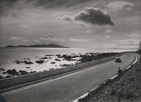
Building the south end of the sea wall for the Centennial Highway, Paekakariki [1939]. Ref: 1/2-057679-F. Alexander Turnbull Library, Wellington, New Zealand. http://natlib.govt.nz/records/22732704.
Celebrating the highway
The new coastal road as well as the Ngauranga Gorge Road were officially opened on 4 November 1939. This event was contemporary with the Centennial Exhibition at Rongotai which opened four days later on 8 November 1939. The road has been referred to as Centennial Highway ever since.
While that title is most commonly taken to be the section of coastal road between Pukerua Bay and Paekakariki, the Centennial Highway is actually the whole length of road from Ngauranga Gorge (via the main road through Tawa township) to the southern-most end of Paekakariki. Although the road was opened at the requisite time to serve the purposes of the Centennial, it was not completely tar-sealed and fully accessible to the public until Christmas Eve 1939.
The coast road was described by the Minister of Public Works, Hon R (Bob) Semple as the most notable major road work of the Centennial year. It cut over four miles off the old route, its highest point was 290 feet, compared with 815 feet on the old route, and the gradient was also more or less halved from one in nine to one in 17 on the average. It cost £350,000 for nine miles of road including the Paekakariki seawall. Semple was quoted as saying at the time that people had forecast that the Government would empty the Treasury into the Tasman before it was finished. In fact the job was finished twelve months ahead of schedule and came in under cost.
A memorial stone cairn and fountain, and a commemorative plaque were constructed in one of the lay-bys along the Paekakariki seawall and were unveiled at the opening.
More information
Access
In the Ngauranga Gorge section the alignment of current 6 lane divided SH1 matches the 1939 alignment of the 4 lane divided "Centennial Highway", which was a radical relocation, made possible by developments in construction machinery. Detailed record is now mainly photographic and written.
Further reading
‘The Centennial and progress,’ Ministry for Culture and Heritage, updated 20 December 2012.
Additional image gallery details
Centennial Highway (Paekakariki Coast Road) under construction, Wellington [circa 1939]. Beattie, Mr: Photographs and negatives relating to the construction of Paekakariki Road. Ref: 1/2-115766-F. Alexander Turnbull Library, Wellington, New Zealand.
Raine, William Hall, 1892-1955. Centennial Highway, Wellington region - Photograph taken by William Hall Raine [circa July 1949]. New Zealand Free Lance: Photographic prints and negatives. Ref: PAColl-8983-67. Alexander Turnbull Library, Wellington, New Zealand.
Building the south end of the sea wall for the Centennial Highway, Paekakariki [1939]. Ref: 1/2-057679-F. Alexander Turnbull Library, Wellington, New Zealand.
Permission of the Alexander Turnbull Library, Wellington, New Zealand, must be obtained before any re-use of these images.
Location
State Highway 1, Ngauranga Gorge to Paekakariki.