The dramatic collapse of the Rangitīkei River Bridge at Bulls in 1973 led to a better understanding of scouring in New Zealand rivers and prompted new design rules.
First and second bridges at Bulls
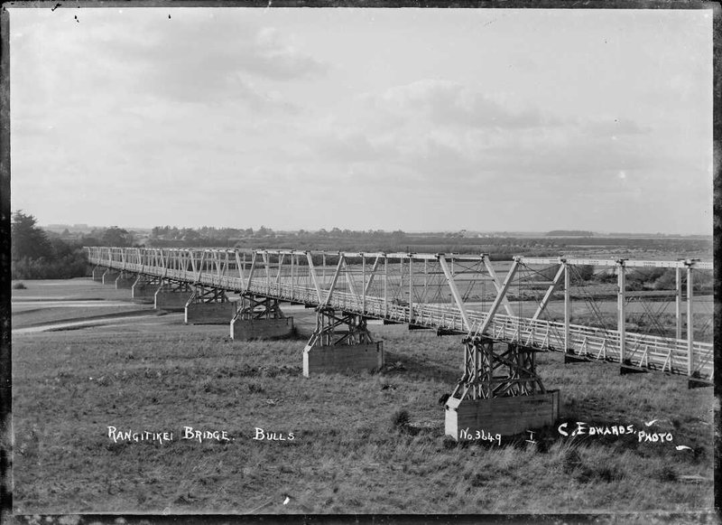
The current bridge across the Rangitīkei River at the southern entrance to the town of Bulls is the fourth to sit at this site. The first bridge was constructed in 1873 by the Wellington Provincial Council. It was destroyed in the great flood of 1897 which washed away all bridges on the Rangitīkei River. After much debate over its location, a replacement bridge was completed in March 1903. Both of these bridges were of single lane timber through-truss construction.

The second Rangtikei River Bridge at Bulls. Edwards, Claude, active 1922. Rangitīkei Bridge, Bulls - Photograph taken by C Edwards. Ref: 1/2-001816-G. Alexander Turnbull Library, Wellington, New Zealand. /records/23090607
The third bridge 1949-1973
Discussions about a replacement for the 1903 bridge began as early as the 1920s but stalled due to disagreement over funding. From the 1930s, the bridge was managed by the government’s Main Highways Board as part of State Highway 1, and a new bridge was opened in 1949.
This bridge was of steel plate girder beam construction. It had a concrete deck and a footpath on the downstream side. It was 496m long and had piers spaced at 26.8m. The plate girders, in alternate spans were 40.2m long and extended 6.7m past the piers in both directions. In the intermediate spans, a 13.4m bridge drop section was supported on the ends of the continuous girders.
The concrete slab piers were founded on a pile cap supported by driven concrete piles. It is possible that the steel girders may have been made in the Railway Workshops at Lower Hutt.
Collapse
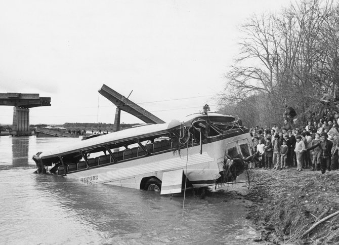
Shortly after 5pm on 15 June 1973, a section of the bridge collapsed, just as a bus was driving over it. The driver described the moment of the collapse: “a great slab of concrete reared up in front of the bus and then I was thrown into darkness". Fortunately, the driver was the only occupant and, although injured in the fall, was able to free himself from the bus and begin to swim to shore. Other motorists arriving on the scene rushed down to pull him from the river.

Weld Motors' bus being hauled from Rangitīkei River, 17 June 1973. Stuff / Manawatū Evening Standard
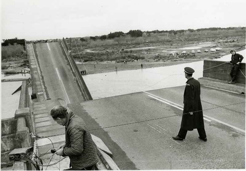
One of the bridge piers had collapsed, its piled foundation scoured out. The collapse dropped one end of the continuous span and tipped the other end up in the air. The drop spans supported on the ends of the continuous span also fell into the river – thus three bridge spans were lost – a gap of 67m.
The river had been flowing hard against the bank and swirling between the pier that collapsed and the bank and back past an old wooden pier from the 1903 bridge. This high flow velocity lowered the bed locally, likely reaching sand layers in the riverbed that would have scoured out very quickly. This seems to be the likely collapse mechanism.
The collapsed pier and piles were never found.
Impact
The loss of the bridge spans cut a number of trunk telecommunication cables and caused serious transport difficulties, particularly for the 200 staff at the nearby Ohakea Air Base who lived in Bulls township on the other side of the river.
A diversion was put in place, redirecting State Highway 1 traffic along country roads to the next river crossing, 13km north east, at Kakariki.

The morning after the bridge collapse. A Post Office worker, left, repairs the cable link. Stuff / Manawatū Evening Standard
Temporary bridge
A temporary Bailey bridge was opened at the site on 30 July 1973 – seven and a half weeks after the collapse.
The river flow was diverted to make the collapse site accessible. The collapsed spans and the remaining pier were demolished, and the site cleared.
A temporary portal type pier was constructed in the middle of the gap. Steel pile sections were brought from Ministry of Works Department stocks in the South Island and 13m high lattice towers were constructed either side of the bridge profile on driven piles. Heavy steel beams were installed as a pier cap to support two 33m long Bailey bridge spans.
The design and height of the temporary pier enabled the permanent span replacements to be constructed underneath it.
New bridge
Replacement piers and superstructure were designed in the Ministry of Works (MOW) Whanganui Office.
At that time computer design analysis of the continuous superstructure beam spans involved sending coding sheets or punched cards to MOW Head Office in Wellington by Railway Road Services bus and return of the print-out sheets the same way – a process of a week or more. The new piers were constructed founded on deep drilled caisson piles.
The new steel girders were fabricated in the MOW power project workshops at Tūrangi. The new spans were of continuous plate girder construction. Project staff from Tūrangi erected and welded the steel beams and a local bridge building contractor from Whanganui constructed the new concrete piers and the deck and footway.
The replacement bridge spans were opened to traffic on 5 December 1973 – less than six months after the collapse.
A further construction programme followed with the provision of new foundations for each of the bridge piers within the river bed. This consisted of new bored piles either side of the existing piers and a concrete beam structure around the existing pile caps. Work was completed during 1974 and 1975.
Learnings and Legacy
The scour failure at Bulls came at a time when there had been scour failures at some other bridge locations around the New Zealand State Highway network. Scour design in the New Zealand river environment was not well understood or recognised and a number of research projects were undertaken, resulting in some new design rules.
A detailed survey and bed analysis of all State Highway bridges throughout New Zealand was completed and a number of at-risk bridges identified. A significant programme of pier strengthening or early bridge replacement then followed.
More Information
Further reading
Stuff, “The night the bridge came down,’ Manawatū Standard, September 01, 2016.
https://www.stuff.co.nz/manawatu-standard/lifestyle/83804335/the-night-the-bridge-came-down
Location
The Rangitīkei River Bridge at Bulls
Entry by Bill Darnell
Page last updated: 31 January 2020


